By Carlos Mendoza | Breaking News
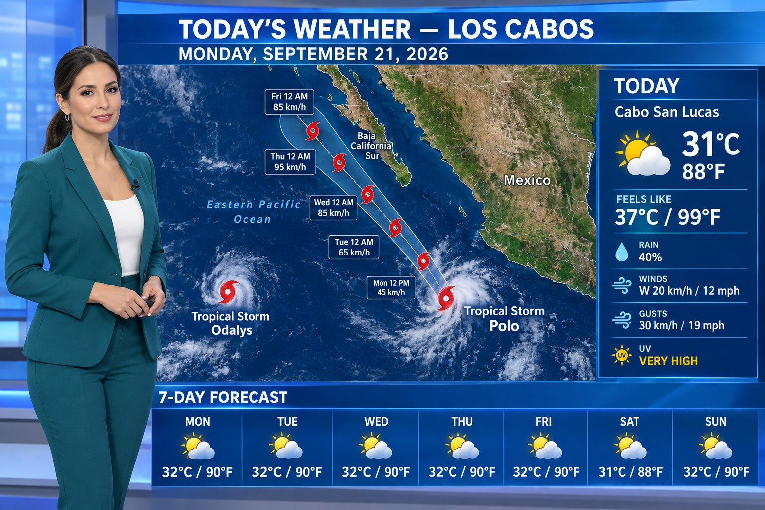
LOS CABOS, BCS — Tropical Storm Polo is strengthening off Mexico’s Pacific coast, and although the storm is not currently over Los Cabos, its projected track makes it a system Baja California Sur residents and visitors should watch closely through the week.
The National Hurricane Center confirmed Monday morning that Polo and Tropical Storm Odalys are both active in the eastern Pacific. Odalys is already well west-southwest of the southern tip of Baja California, while Polo is the system closer to mainland Mexico and the one with the more important developing forecast for Baja California Sur.
Where Tropical Storm Polo is now
BCS Noticias, citing Mexico’s Servicio Meteorológico Nacional, reported Monday morning that Polo was approximately 320 km (199 miles) southwest of Zihuatanejo, Guerrero, and 410 km (255 miles) south-southeast of Manzanillo, Colima, with sustained winds around 100 km/h (62 mph) and gusts near 120 km/h (75 mph).
The storm is expected to strengthen rapidly. Forecast guidance has Polo becoming a hurricane and potentially a major hurricane as it moves over warm Pacific waters. Its projected path brings the system progressively northwestward and closer to the Baja California Sur region later this week.
For Cabo, the key point Monday morning is this: Polo is a storm to monitor, not a reason to panic. Forecast tracks several days out can change substantially, and a projected approach toward Baja California Sur does not mean a direct Los Cabos landfall. Residents, boaters and travelers should follow official updates from SMN/CONAGUA, the National Hurricane Center and Protección Civil rather than relying on individual social-media forecast maps.
Today’s Los Cabos forecast — Monday, September 21
Cabo San Lucas is forecast to reach about 31°C (88°F) today, with a feels-like temperature around 37°C (99°F). The Weather Network gives the Cabo area about a 40% probability of precipitation, with a risk of strong thunderstorms, winds near 20 km/h (12 mph) from the west and gusts around 30 km/h (19 mph).
San José del Cabo is also hot, with afternoon readings around 32–33°C (90–91°F) possible. Humidity will make conditions feel hotter. UV exposure remains very high, so midday sun protection and hydration are important even where skies appear partly cloudy.
Los Cabos 7-day outlook
- Mon., Sept. 21: around 32°C / 90°F high, 26°C / 79°F low; hot with a chance of thunderstorms.
- Tue., Sept. 22: around 32°C / 90°F high, 27°C / 81°F low.
- Wed., Sept. 23: around 32°C / 90°F high, 26°C / 79°F low.
- Thu., Sept. 24: around 32°C / 90°F high, 26°C / 79°F low.
- Fri., Sept. 25: around 32°C / 90°F high, 26°C / 79°F low.
- Sat., Sept. 26: around 31°C / 88°F high, 26°C / 79°F low.
- Sun., Sept. 27: around 32°C / 90°F high, 26°C / 79°F low.
Those temperatures are useful planning guidance, but the tropical forecast is the more important variable. Polo’s evolution could alter rain, wind, surf and marine conditions later in the week even if its center remains offshore.
What Cabo residents and visitors should do now
No special alarm is warranted based solely on Monday morning’s forecast. This is, however, a good time to check travel plans, keep phones charged, know where official Civil Protection information is posted and make sure boats and outdoor property items can be secured if conditions deteriorate.
Anyone planning fishing, charters, surfing or other marine activities later this week should check updated marine forecasts before departure. Conditions offshore can become hazardous well before a tropical cyclone’s center reaches the Baja Peninsula.
The Cabo Magazine will update this report if Polo’s forecast track, intensity or expected effects for Los Cabos materially change.